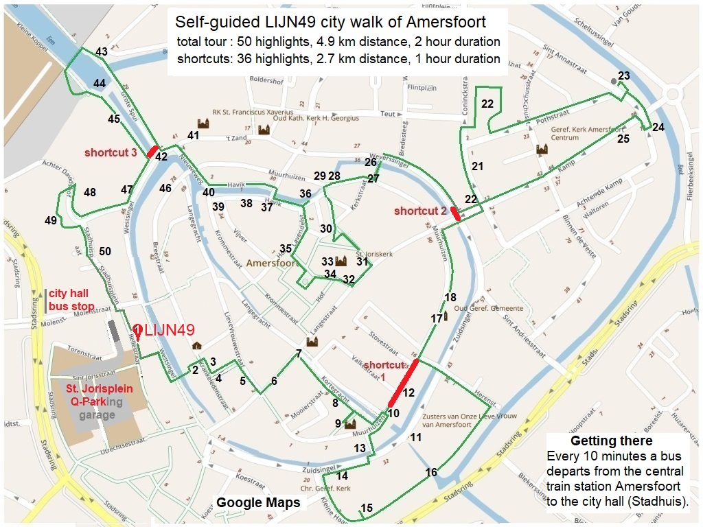
LIJN49 free self-guided 4.9 kilometer city walk with 50 highlights of Amersfoort
Amersfoort is an unique city in the center of the Netherlands. It is the only town in the Netherlands where the first city wall was converted to houses (wall houses) when the second city wall was built. When you walk through the streets and the many market squares of the inner city of Amersfoort, you wander back in time to the middle ages.
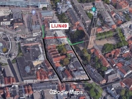
The total duration of the full tour is two hours (one hour walking and one hour sightseeing). When you take the shortcuts, you will still see 36 The map below shows the entire route in green with the shortcuts in red. These shortcuts are also added as (red) fast forward button in the detailed city walk description.
Usage and copyright
The LIJN49 city tour is free to use and may be used by any tourist visiting Amersfoort. All content is published under the CC BY-NC-SA copyright, meaning the content may be used non-commercially, as long as Lunchroom LIJN49 is credited and it is licensed under identical terms (for free).
Legal disclaimer
LIJN49 can not be hold responsible for errors in the provided information nor any injury or loss occurred by walking this free self-guided tour or visiting any of the highlights.
–
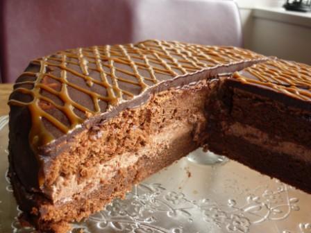
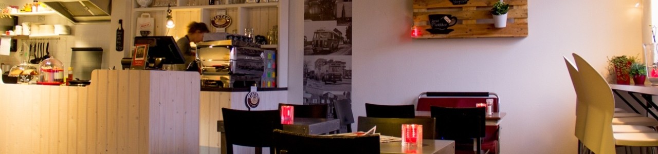
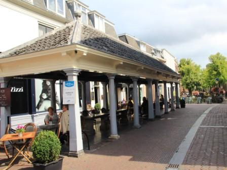
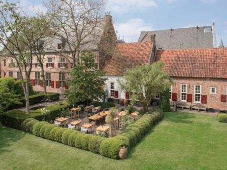
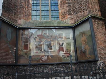
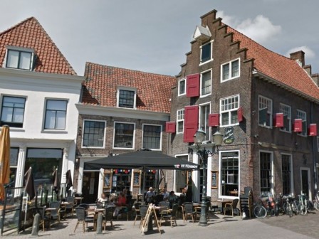
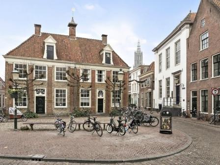
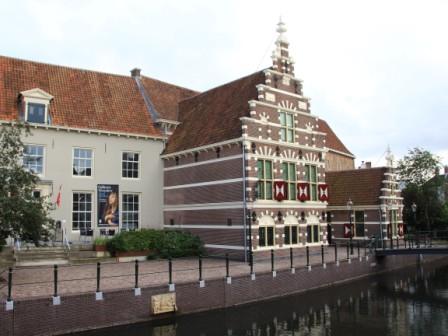
1. Lunchroom LIJN49 (Hellestraat 49)
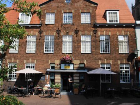
Lunchroom LIJN49 is also a protected monument. It is built in an architectural style which emerged after the second world war at the technical University of Delft.
This style (the ‘Delftse School’) is known for its sober and rational design using traditional brick building techniques. Construction mass should be in balance with space and light. Less is more is one of the well-known guiding principles of this Dutch design style.
Facing LIJN49 turn right. After 25 meters, take the passage on the left before the supermarket. The passage is normally open from 08.00 to 22.00 and from 10.00 to 20.00 on Sundays.
When the passage is closed, continue another 100 meter on the Hellestraat and turn (first) left into the Utrechtsestraat. After 60 meters take the (first) left into the Westsingel. After 90 meters you will see the pedestrian bridged across the canal to the tower.
–
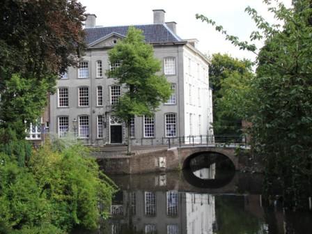
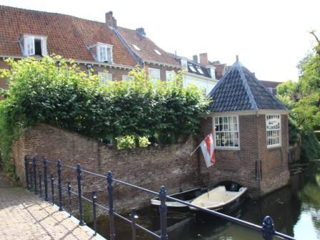
2. OLV toren – tower of Our Lady (Krankeledenstraat 30)
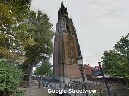
Our Lady tower is nicknamed ‘Lange Jan’ (Long John). It was completed in 1460 and is 98.33 meters high. Because Amersfoort was part of the Archdiocese of Utrecht, the tower had to be shorter than the DOM tower of Utrecht (which is 112,32 meters).
The tower was built with the gifts of pilgrims who came to see the statue of the virgin Maria which was displayed at the chape house (see 4) This Maria statue was supposed to have divine healing powers. Walk across the canal bridge to the entrance of the tower (at the other side) for a peek inside the tower.
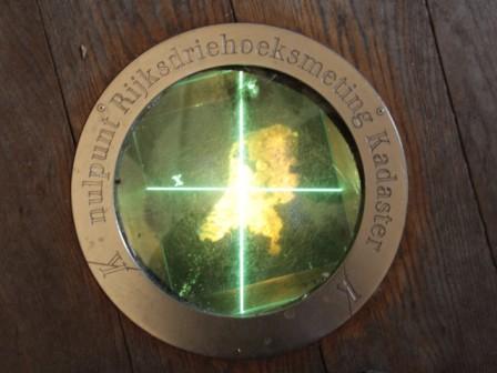
Outside the church you will see a grey X- and Y-line. The tower was the geographical center (zero coordinate) until previous century. The zero reference was moved into the North Sea, so all coordinates are positive (prevent plus/minus mistakes). On the floor inside the tower the former zero coordinate is marked.
The doors are often open because it is possible to climb 346 steps to the third stage of the tower. Ask at the tourist office at the Breestraat 1 at the corner of the square. The turret at the corner were the Y-axis is marked on the ground, is a little bigger than the other three. The tower and the larger turret symbolize the Virgin Mother Maria holding the baby Jezus.
–
3. Lieve Vrouwkerkhof – Our Lady square with contour of church
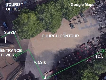
During the Dutch Rebellion (between 1781 and 1795) republicans tried to reduce the power of the regent Prince William the fifth of Orange. Amersfoort was an Orangists’ stronghold. When the rebellions chased the William the fifth out of the Hague, the Prince fled to Amersfoort and temporarily stayed in the ‘house with the purple windows’ (see 11).
At that time the church was used as an arms depot. In August 1787 it exploded due to an accident with gun powder (they did not had ‘smoking kills’ health warning on cigarette packets in those days). The tower survived the blast, because it was build on the firm foundation of the city wall. The contour of the church is still visible on the square. The Chapel house is on the lower corner of the square (marked 4)
–
4. Kapelhuisje – chapel house (Krankeledenstraat 11)
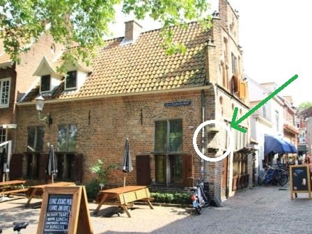
The Chapel house dates back to 1520. At the corner of the ‘Lieve Vrouwekerkhof’ and the Krankeledenstraat you will see an empty shrine. This was the shrine where the statue of the Virgin Maria statue was displayed.
The name of the Krankeleden street refers to the ill (kranke) people (leden) walking passed the Maria statue hoping to be healed by the Miracle of Amersfoort.
Continue on the ‘Lieve Vrouwenkerkhof’ to the corner of the square. At the end turn right into the ‘Lieve Vrouwestraat’.
–
5. Medieval wooden houses (Lieve Vrouwestraat 6 and 8)
During the 80 year Dutch independence war from 1568 until 1648 Amersfoort was under siege a few times. Many wooden houses were destroyed by fire caused by the daily canon shootings during a siege.
To reduce the risk of fire, the city council decided in 1645 that all wooden houses had to be converted to brick houses. A smart tavern owner only replaced the woorden façade with brick to prevent downtime and loss of business. Not only did they save costs, but they also saved these old wooden houses (built before 1540) for future generations.
Take the first street left at the end of the ‘Lieve Vrouwestraat’, called the Langestraat (long street).
–
6. Langestraat – long street
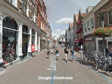
This shopping street runs straight through the old city center and was first hardened around 11th century with 5.6 meter trees (wide enough to let two horse carts pass). Langestraat (long street) was paved after Amersfoort got its city rights in 1259.
It got its name because it simple was the longest street at that time. Some shop facades still reveal their history like the shop on number 45 which is marked ‘anno 1628’ (built in 1628).
After just 80 meters turn right to the Kortegracht (short canal) at the vishal (fish market).
–
7. Vishal – fish market (Kortegracht 1)
When you notice this small open building on the right, turn right into the Kortegracht. This open building from 1657 was used as a fish market. The fishmongers used to prepare and sell their fish on the hard stone tables in the fish market.
The stone tables are from a similar fish market from the city of Haarlem. When they converted the market to tourist shops in the previous century Amersfoort got the hard stone tables to complete this national monument.
–
8. Mondriaanhuis – Mondriaan house (Kortegracht 11)
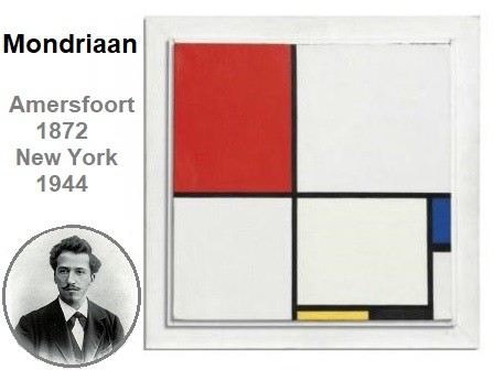
Halfway the Kortegracht you will find the Mondriaanhuis. This is the house where the painter Mondriaan was born. The museum gives an impression of his work and life. It is open from Tuesday to Sunday from 11.00 to 17.00 hour.
He was one of the pioneers of abstract art, known for his squares in red, yellow, and blue. Composition no 3 was sold for 44 million euro (50 million dollar) in 2015 in New York.
Story goes that he was as square as his paintings and used to de-friend fellow artists, just because they used an arch or round shape in their paintings. A few meters further on the right, have a look at the synagogue in the Drieringensteeg.
–
9. Joodse synagoge – Jewish synagogue (Drieringensteeg 2)
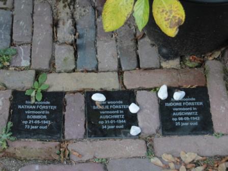
The first Jewish merchant came to Amersfoort in 1650. Jewish merchants and traders propelled the emerging tobacco industry in Amersfoort. Because of their contribution to the local economy they were allowed to build a synagogue in 1727.
Amersfoort, like Amsterdam, had a flourishing Jewish community. Sadly they suffered heavily in the second world war. The little black memorial stones in the Drieringensteeg, close to the Synagogue entrance, are a reminder of this black page in European history.
Walk back to the Kortegracht again and turn right to proceed to the Muurhuizen (wall houses).
–
10 Tinnenburg – battlements house ( Muurhuizen 25 )
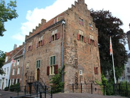
Tinnenburg, at the end of the Kortegracht, is one the oldest wall houses (Muurhuizen). It was converted to a merchant house in 1414 when the second defense wall was built. You can still see the contour of the 7 meter high and 60 cm thick wall.
All ‘muurhuizen’ with ‘burg’ in their name probably were strongholds (burg means fortification) in the first city wall. Tinnen is old Dutch for battlements. The battlements visible at the front and back of the roof of the house probably gave this house its name.
In the 16th century Tinneburg was converted to spinning mill where the cildren of the nearby Weeshuis (see 14) were put to work. Child labor was quite common and kids often worked in mills and factories.
–
11 Huis met paarse ruiten – purple windows house ( Zuidsingel 38 )
Walk to the iron fence on the stone bridge below Tinnenburg and look across the water to the east to see a Louis 16th style house with purple windows. The windows get their color from the mineral manganese used in the glass of the windows. This type of glass was very popular when it was was built in 1780.
During the Dutch rebellion Benjamin Cohen offered this residence to Prince regent William the 5th of Orange. The meetings of the 40 members of the ‘Staten Generaal’ (parliament) were also located to Amersfoort (only the 20 to 25 loyal members followed the Prince to Amersfoort).
Walk a few meters into the Muurhuizen (until your are parallel to the stair entrance of Tinnenburg).
–
12 Gasthuys – former St. Elizabeth hospital (Muurhuizen 33 )
Looking up into the Muurhuizen, you see a white building with an octagonal tower. From 1578 until 1907 this was the Saint Elizabeth Hospital. It was the first hospital in Amersfoort founded by the brother hood of the holy spirit (also known as holy trinity). Only people not having contagious deceases were taken care of.
When you want to take the shortcut, walk towards the St. Elizabeth hospital and continue walking on the Muurhuizen to number 97 (and press the red button below). When you want to continue the route with the next highlight (Bollenburg) turn back and walk south until you see the ‘Weeshuisgang’ (orphanage passage) on the left. This passage takes you across the city canal. Turn right at the Zuidsingel.
–
13. Bollenburg – skittles house (Muurhuizen 19)
Bollenburg was built in 1398. It was converted from a stronghold to a house in the 14th century. In 1547 the Secretary of State Johan van Oldenbarnevelt was born in this house. He was the initiator of the Dutch East Indies Company (VOC). The VOC was the first stock funded company in the world in 1602 (making the Dutch stock exchange also the oldest in the World).
In the 16th century it became a spinning mill (like neighboring Tinnenburg). In the 17th century it was an inn where one also could play skittle (‘bollen’ in old Dutch), which explains its name.
Probably because the children of the ‘Burgerweeshuis’ orphanage (see 14) walked to and from the mills at Bollenburg and Tinnenburg, the connecting passage was called the ‘Weeshuisgang’ (orphanage passage).
Continue southbound on the Zuidsingel.
–
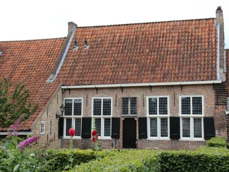
14. Burgerweeshuis – orphanage home (entrance before Zuidsingel 23)
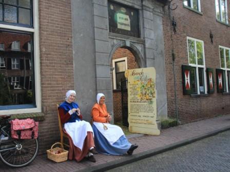
The Saint Nicolas orphanage was founded in 1551. It moved to this location (including the Mariënhof see 15) in 1612 and remained an orphanage until 1929. In July and August you can visit this orphanage for free and travel back to the 16th century thanks to the role players of ‘living history’ Amersfoort.
Proceed south on the Zuidsingel and turn left at first street called ‘Kleine Haag’. At the end of the ‘Kleine Haag’ (just after 100 meters) follow the brick wall on the left (which turns into the park).
–
15. Mariënhof – Maria’s court (entrance on Plantsoen Zuid)
This convent was built in 1479 by the Black sister of Saint Ursula (Cellezusters). They were called the black sisters because they also cared for people suffering from the plague. The plague was nicknamed the black death (hence black sisters).
The black sisters moved to ‘Armen de Poth’ in 1547 (see 22). The monks of the brotherhood of Augustine moved back to Amersfoort in 1543 who named it Maria’s court after their monastery in neighboring village Soest was demolished by Maarten van Rossum, a field general of the Duke of Geulders (Hertog van Gelderland) feared for his ruthless actions against citizens. With the surrender of Geulders , all counties of the Netherlands came under the rule of the king of Spain (emperor Charles the Fifth).
Continue to walk to the Monikkendam watergate.
–
16. Monnikendam – second wall watergate (Plantsoen Oost)
This double tower watergate was built approximately around 1420 as part of the second city wall. Its main purpose was to control the water level by either allowing it to flow into the city or reroute it into the canal on the outside of the second city wall. It is probably named after the Augustine monks which lived at the ‘St. Andrieskamp’ from until 1420 and returned to the Mariënhof in 1543.
‘Plantsoen Zuid’ (South park) becomes ‘Plantsoen East’ (East park) when you cross this watergate. Continue to walk into the East park until the first street on the left (called the Herenstraat). Walk strait over the canal bridge (called the Schoutensteeg) and turn right into the Muurhuizen.
–
17. Dieventoren – thief’s tower (Muurhuizen 97)
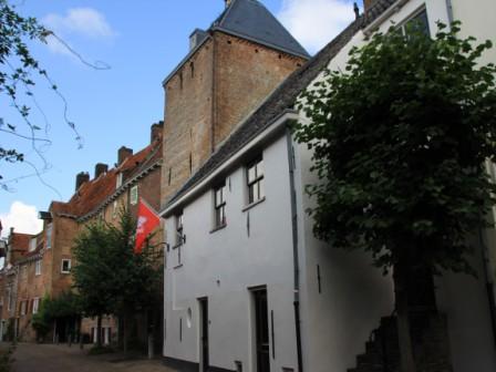
It’s square shape makes it vulnerable for incoming cannonballs. Gunpowder was (re)discovered in the 13th century in Europe. That is why historians think it is early 13th century when the Archdiocese of Utrecht was often at war with the Duke of Geulders. It would make sense to build fortifications on the east side of the city (the province of Gelderland side) before constructing the first defense wall around the city.
It was first mentioned in 1434 when the city prison was moved from beneath the city hall to this tower. It probably got its name because it remained a prison until 1889.
Continue to the Muurhuizen 109 (Secretarishuisje).
–
18. Secretarishuisje – city secretary house (Muurhuizen 109)
Built in 1560, this house got its name because it was redesigned by the Amersfoort city secretary Jan Both in 1776. He was from an influential family with many politicians. One of his ancestors was Amersfoort born Pieter Both, who was the first governor of the Dutch East Indies.
Due to its odd and characteristic placement of windows, it deserved a place in the KLM Delft blue miniature ‘houses of Holland’ gift series. When you are so fortunate to fly business class, ask for house number 89, the Secretary house.
Proceed and turn right at the first street.
–
19. Kamperbinnenpoort – city gate (between Langestraat en Kamp)
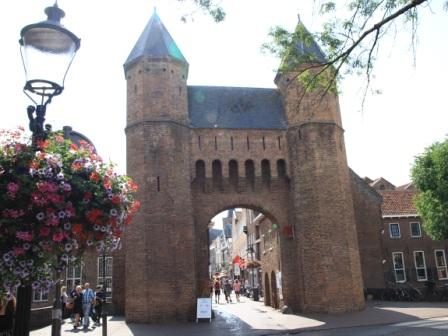
The Kamperbinnenpoort or Viepoort was first mentioned in 1381. It was the city gate (poort) where cattle (vie in old Dutch) was held in a corral (Kamp, derived from the Latin word campus) before being sold at the market in Amersfoort.
Its inner courtyard is the shortest street of the city. The Kamperbinnenpoort (street) connects the Langestraat (long street) with the Kamp (coral).
Walk through the gate and immediately turn left onto the Weverssingel when you want to take the shortcut, (continue with 26), otherwise proceed on the street called Kamp (continue with 20).
–
20. Gekroonde Byenkorf – former warehouse (Kamp 10)
Initially the Kamp provided a safe ground for traders selling cattle on the markets. When the city expanded in the 17th century (from 1601 to 1700), this area was converted to ware houses.
The warehouse on number 10 is built in 1687 and has a gabble stone above the second window. It represents a beehive with a cherub (angel) on each side. The beehive probably refers to its use as a warehouse.
The warehouse continues in the Coninckstraat (King’s street). Pully hand cranes above each windows were used to hoist goods through the windows. When you look closely you will see it even has a door for larger objects. Continue into the Coninckstraat.
–
21. Tabaksplant – former warehouse (Coninckstraat 15)
This 17th century store house is converted to a boutique hotel the Tabaksplant. Its name refers to its old function of drying tobacco. Breeding boxes and drying houses were Dutch innovations to deal with the wet Dutch climate.
In 1604 the production of tobacco was banned in the United Kingdom. Some farmers emigrated to the Netherlands and discovered that the sandy soil around Amersfoort was very suitable for growing tobacco. The first tobacco farmer started in 1615 and in 1680 over 200 farmers were registered in the tobacco guild.
–
22. Armen de Poth hofje – black kettle almshouses (Coninckstraat 41)
The brotherhood of the holy spirit provided shelter and bread for the poor. The brotherhood moved to this location in 1525, because it already had a chapel (built in 1500). In those days the Roman Catholic church used to shuffle with nuns and monks of different branches depending on their size and succes (and need for housing). This were the same monks which started the Saint Elizabeth Hospital in 1578 on the Muurhuizen 33 (see 12 Gasthuys).
The English information on the website of the Black kettle almshouses (link) mentions that by chance this court was already named Pothof (kettle court). But in those days it was quite common to use a (black) kettle as a collection box for donations (so the people donating money, knew their gifts were used to feed the poor). This explains the black kettle wall plague above the entrance on the Conickstraat 41.
In 1547 the Black Sisters (Celle zusters) from Maria’s court (15) moved in. They gave the name to the existing chapel Sint Rochus (Saint Roche). Saint Roche is the patron for people suffering the plague. The black death was contagious and killed millions of people in Europe from 1347 to 1772. The high mortality rate also had its impact on the nuns until they were with so little nuns that they could fit into one house (black sisters house is pictured).
Initially all plague sufferers were nursed in a common shared house, but in the 16th century eight houses were added, so rich people could hire these houses. When the plague outbreaks ended these houses became available for poor and homeless people. Today the 48 houses are still available for old and poor people of Amersfoort. Until 1975 the residents got one bread loaf per week from the bakery. The bakery is on the left of the black sisters house.
Walk to the St Rochus chapel, take the exit on the Pothstraat and turn left.
–
23. Miracle of Amersfoort (Plantsoen Noord)
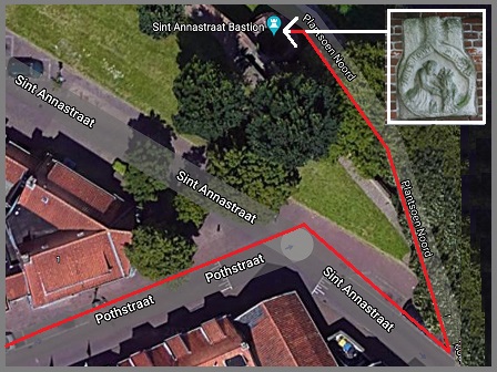
At the end of Poth street, turn right into Sints Anna straat, after a few meters the wall ends. Go around the wall into the park (Plantsoen Noord) and look for the sign in the wall of the ‘Miracle of Amersfoort’.
In 1444 a poor girl (Geertje Arends) was joining the nun. She had a Maria statue as a gift. Because the clay statue was simple, she did not dare to give it to the nuns and threw in the river Eems.
On Christmas eve another girl (Grietje Ghysen) got three visions in which Maria urged her to retrieve the statue. She found the statue at this exact spot and gave it to a clergyman (Jan van Schoonhoven). Immediately miracles started to happen and Amersfoort became an pilgrimage city.
Walk back to the Annastraat, in front of you on the left you will see the second city wall and some defense turrets on the left. Walk to the Kamp.
–
24. Tweede stadsmuur -15th century second city wall (Achter de Kamp 256)
The second wall was build from 1380 to 1450 and tripled the living space. It was 2850 meters long and had eight gates.
After the economic boom, the city started to decline economically in the 18th century. The stones of the city walls were used as cheap building material for houses. This ended in 1844 when King William the first of Orange (Koning Willem 1) forbid further breakdown and demolition of city walls and historic building.
This area ‘Achter the Kamp’ (behind the corral) was used as a safe ground by cattle traders until the end of 17th century. Maybe because the houses in this neighborhood were relatively young, the north east of the second city wall (partly) survived the plundering of stones.
This part of the wall was restored to its original state between 1973 and 1978. It shows how the second city wall must have looked like in the 15th century. Walk back to the Kamp and return to the city gate of the first city wall (Kamperbinnenpoort).
–
25. Find the16th century gabble stone houses on ‘de Kamp’
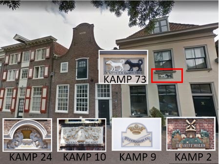
House number 73 on Kamp number 73 has a gabble stone representing a black and a white dog. Gabble stones and wall plagues were used from the 16th to the 18th century to identify houses and shops.
Shops often used signs related to their business, but houses often had fantasy names or images. Four other houses have shop signs on this street. Look for a beehive with cherubs (“D’ Gekroonde Beijnkorf” on number 10), a candle basket (“De Keerskorf” on number 24’), a measuring rod with a crown (“D’ Gekroonde El” on number 9) and a wind mill (‘De Snuif Molen’ on number 2).
Walk back to the Kamperbinnenpoort and turn right at the Weverssingel (weaver’s canal), that is the street just after Kamp 2 with the wind mill gabble stone.
–
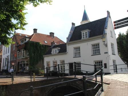
26. Theehuisje – Tea house in the canal (view from Westsingel)
Facing the Kamperbinnenpoort turn into the Weversingel (weavers canal). In the 16th and 17th century the economy of Amersfoort flourished due to the textile and tobacco industry.
The textile industry payed half a dime for a bucket of urine (approximately the price of half a bread in the 15th century). They used urine to clean and paint wool. Because the canals were relatively clean, the wall houses became a popular domicile for rich merchants and influential politicians.
The thee house in the canal was first mentioned in 1735. A popular story says that the city secretary Diederik Schagen used his influence to build a thee house in the canal, despite a law requiring the canal to be easy navigable for ships. This is probably the reason why it is the only thea house build in the canal in Amersfoort.
Take the pedestrian bridge (called the Blauwebruggang) across the canal and turn right into the Muurhuizen again.
–
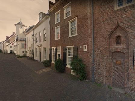
27. Muurhuizen – picture the middle ages (Muurhuizen 177 to 159)
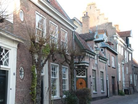
Walking through the Muurhuizen, is like travelling back in time to the middle ages. The inner city of Amersfoort has over 400 national monuments and over 4000 municipal monuments and protected facades. For reference Amsterdam has over 8500, but the periphery of the 17th century inner city of Amsterdam is 13 kilometers, while the periphery of the 15th century inner city of Amersfoort is less than 3 kilometers. Per square mile Amersfoort has four times as much points of interests than Amsterdam.
The medieval city center of Amersfoort with its many squares, terraces, shops, restaurants and pubs will ensure you have an enjoyable day in Amersfoort.
Amersfoort also has some interesting musea: Museum Flehite (art and history), , Mondriaan house, Rietveld pavilion (photography), Musiom (temporary art), and Kunsthal KAdE (moderne art).
Continue on the Muurhuizen (not the viewing direction of the picture but the reverse direction with increasing house numbers 177 – 179 – 181) t
–
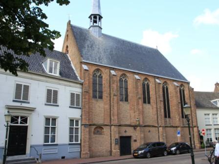
28. Sluijsje & Musiecqzaal – sluice & music hall (Muurhuizen 199)

The first reference of ‘het Sluisje’ (sluice) dates back to 1492. Originally it was a wooden sluice to control the water from the outer canal to the harbor. The house on number 199 was built over the sluice when the stone bridge to the Havik (old harbor) was build in 1593. Today the canal still runs below this house.
It was a forge until the merchant Abraham Italianer bought it and used it as a tobacco warehouse until 1755. The rich tabacco merchant Benjamin Cohen bought it for the local ‘music college Concordia’ Above the door you will first notice the text ‘Sluisje’ and in the grey stone above the text ‘musiecqzaal’ (music hall).
Above the door of the music hall the founders of this ‘music college concordia’ are mentioned with the year notation MDCCLXXVI (1776). It was used for concerts and music education until 1882.
Walk towards the small octagon shaped tower on the right about 10 meters down the Muurhuizen. This house is also confusingly numbered 199 (a through d) and is called Prattenburg (explained below).
–
29. Prattenburg (also Muurhuizen 199)
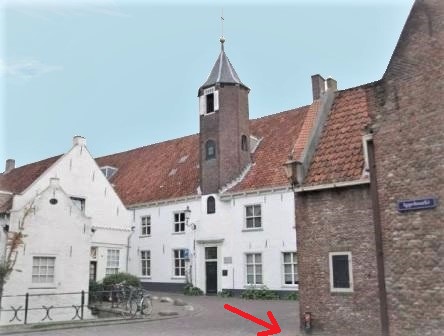
Prattenburg is one of the olderst buildings of the first city wall. Together with other fortified building, Bollenburg and Tinnenburg, it former the backbone of the 14th century city’s defence system. Prattenburg was the largest of the ‘burg’ (fortified) houses, it now hosts 42 luxury apartments.
One of the members of the local influential Zoudenbalch family (Evert) was major of the city of Utrecht and had purchases an estate called Prattenburg, giving him the title lord of Prattenburg. His son Hendrick became the city councelor of Amersfoort in 1568. The stair in the tower has a date notation of 1567, so it might have gotten the name Plattenburg, because the lord of Prattenburg lived in this stately house or simply because an owner was proud on it (prat is proud in Old Dutch). There are a few other estates in the Netherlands called Prattenburg for this reason.
Walk towards the place where the picture is taken as indicated by the red arrow. This is triangular square called the Appelmarkt (apple market). Walk towards the St Joris (Saint Georg) church on the Groen markt (‘green’ or vegetable market).
–
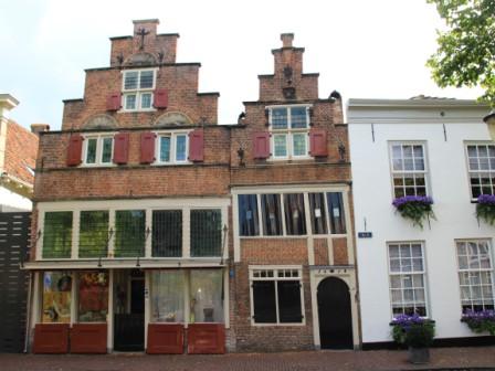
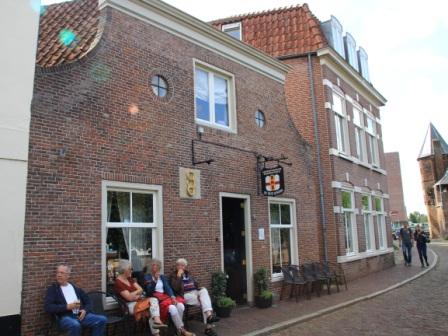
30. Mandaatshuisje – pub ‘Onder de linde’ (Groenmarkt 9)
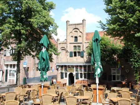
In 1317 the ‘Papenhofstede, Appelmarkt en Groenmarkt’ were added to the mandate of the (Saint George) church in 1317 to host a chapter of monks. This implied that the police had no jurisdiction in this area.
This ‘mandate’ house was built in 1520 and rebuilt in 1530 after a fire. The oldest reference of ‘Onder de linde’ being a pub is from 1755. It is one of the two oldest pubs in Amersfoort (controversy explained at the other oldest pub of Amersfoort). When the terrace is open take a brake to enjoy the sun and the atmosphere of this medieval market.
Facing the pub (as on the picture), walk back to the Groenmarkt (keeping the church on the right and the pubs on the left). Note the small houses between the alcoves of the Saint George church (the Saint George cross is also te coat of arms of the city of Amersfoort). At the end of the Groen Markt turn right into the Langestraat.
–
31. Fresco on the outside of Saint George church (before Langestraat 86)
This wall painting was discovered in 1901, when the night watch house was broken down. The night watch wandered through the city at night only armed with a club to prevent crime calling out loud what time it was.
Fun fact: The famous painting of Rembrandt does not picture the night watch, but the sheriff and his militia. The real title of the painting is “The company of Captain Frans Banning Cocq and Lieutenant Willem van Ruytenburgh “.
The fresco is dated between 1600 and 1625. It represents Christ Carrying the Cross with Saint Veronica offering him a towel to wipe his (Jezus) face. By miracle the image of Jezus appeared on the cloth. The painting outside is a replica. The original is moved to the inside the church near the altar.
Continue on the Langestraat (to the left when facing the fresco) to the ‘Hof’ (the main city square of Amersfoort).
–
32. In den Grooten Slock – the other oldest pub (Zevenhuizen 1a)
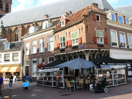
‘In den Grooten Slock’ literally translates to ‘in the big sip’, but means something like ’to have a glassful’ (of beer). Historians date this building to early 16th century without exact date. The distinct shape of the building of is already visible on a city map of 1588.
The owner claims this building is from 1522 and was a pub right from the start. Because this claim is not backed up by official documents we refer to the “In den Grooten Slock’ as the other oldest pub of Amersfoort.
Dutch law requires a pub to be at least 30 square meters. Officially this pub is to small, but because it was a pub before this legislation applied, it is allowed to serve beer and spirits. When you want to picture Dutch coziness “gezelligheid” this tiny pub is certainly worth a visit.
Continue on Zevenhuizen street to the main city square called ‘de Hof’.
–
33. Sint Joris kerk – Saint George church (Hof 1)
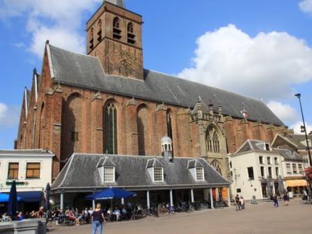
The ‘Hof’ is short for bisschopshof (Bishop’s court). It was first mentioned in a certificate of 1196 as a place where the Bishop was allowed to collect taxes.
The construction of the tower started around 1200. The first part (aisle hall) was completed in 1248. The second aisle hall was probably added in 1350 and the third in 1534. As a result of this incremental expansion the church has three organs also. This explains why the tower is part of the first aisle hall, where as most catholic churches and cathedrals have the tower in the largest middle section.
The grave of Jacob van Kampen is inside this church. He was a famous architect from the Dutch Golden Age who designed the Royal Palace of Amsterdam (former City Hall 1647), the Maurits house in the Hague, teh ‘New Church’ in Harlem (1659) and the Noordeinde Palace in the Hague (1640, the domicile of the King Willem-Alexander).
The square got its central market function in the 15th century when the city hall was built on it. There are many interesting buildings from the 16th, 17th and 18th century buildings on the square. Have a drink on one of the terraces (or at the ‘other oldest’ pub of Amersfoort) when you want to wait for the carillon to play (34).
–
34. Carillon above butter market (on the Hof in front of the church)
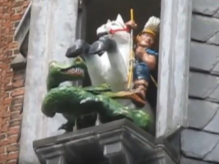
According to old belief the dragon hides in the 15th century fountain at the center of the square. Every hour the carillon plays above the old boterhal (butter market). The butter market looks similar to the fish market you saw earlier on this tour (7). The butter market was built in 1608 as a cool and dry place to to sell butter on the central market square by local farmers.
Exactly on the hour the doors below the carillon open and a green dragon appears, immediately followed by Saint George on his white horse. With a few blows of his sword Saint George chases the dragon away.
Ancient belief says the dragon hides in the well in the center of this market square. As long as Saint George is the patron Saint of Amersfoort the inhabitants of Amersfoort are protected against the dragon. The Saint George worship also explain why the Saint George cross is on the coat of arms of Amersfoort.
Walk clockwise around the square until you see Hof 9 (no 32) at the corner of Lavendelstraat.
–
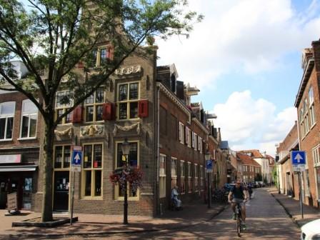
35. Typical 17th century architecture trading house (Hof 9)
This is one of the trading houses built in the typical 17th century style architecture. In the 16th and 17th century the economy of Amersfoort was booming due to the beer, textile and tobacco industry.
With its markets Amersfoort tried to take business away from the nearby ‘Hanze steden’ (Hanseatic cities) Deventer, Harderwijk, Zwolle, and Kampen. These cities were on the trading route to Germany. The large central market square played an important role in this agricultural trade competition.
Besides offering a lot of markets to traders and merchants the city board decided to increase logistics also and fund a ambitious project. Amerfoort already had a good connection to Amsterdam via the river ‘Eems’. To improve the connection to Utrecht the earlier mentioned architect Jacob van Kampen designed the ‘Wegh der Weghen’ (road of all roads). This was 17 meters wide straight road from Amersfoort to Utrecht, was the first highway in Europe.
Exit the market at the Lavendel straat (lavender street) which is right besides the pictured merchant house at the Hof 9.
–
36. Liefdehuis – caring home ’the end of the world’ (seen from the Havik)
The name Havik is a concatenation of two old Dutch words ‘haf’ and ‘vik’, meaning harbor (haven) and fold (vouw). Until 1430 this bend in river the Eem was the harbor of Amersfoort.
Coming from the Lavendelstraat on the Havik, walk a little to the right. On the other side of the channel you see the caring home (‘liefdehuis’) of the sisters of the Saint Joseph convent. This charity foundation still exists today, only with a different focus (to support elderly living groups).
Because it was the caring home for the poor and incurable ill, it got nick named the end of the world (“Einde van de Wereld”). The wooden shed near the water (on the right corner of the picture) with the vertical stripes, was the place where the nuns washed the (bed) clothes and linnen.
Walk to the bridge on the Havik (visible on the left of the picture).
–
37. The smallest house of Amersfoort (Havik 33)
Havik 35 en 33 were built in 1618 and now are the studio of a local painter called Norbertus whose work is a colorful cross over of naïef and modern art.
Havik 33 is the narrowest house in Amersfoort. It is only 3 meters wide and it only has a front and back wall. It uses the walls of the adjoining houses to support the roof and first floor.
Some claim the house on the Westsingel 27 is the smallest house of Amersfoort, but that house is 3.2 meters, but that is whopping twenty centimeters wider.
So besides an oldest pub controversy, Amersfoort also has a smallest house dispute. Some say, because Havik 35 and 33 are united (a part of the shared inner wall is removed), Havik 33 is not a separate living house anymore and Westsingel 27 is the rightful owner of the ‘smallest house in Amersfoort’ title. Others say Havik 33 is still a separate house because it has its own entry in the official land and real estate register of the Netherlands.
Proceed on the Havik to number 25.
–
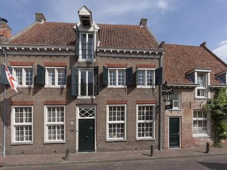
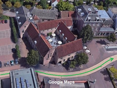
38. Gallery 1664 (Havik 25)
The date in Roman numerals (MDCLXIIII) is the date when this beautiful 17th century bouse was built. It is nearly impossible to take a nice picture of it (because of parked cars), so this picture is from Google maps.
After the second wall around Amersfoort was build, the harbor moved outside the city further down stream the river Eem (after the combined land and watergate the Koppelpoort). The warehouses on the Havik (the old harbor) became craftsman’s houses until 16th century. During the Dutch Golden Century (in the 17th century) regent and trading families bought these houses and converted them to mansions illustrating their influence and wealth.
It hosts a small art gallery that changes exposition every three months. The art displayed ranges from classic to modern art. The gallery is open on Fridays from 14.00 to 17.00 and on Saturday from 12.00 to 17.00.
Proceed on the Havik to house number 11.
–
39. VOC Huizen – Dutch East Indies Houses (Havik 11 and 13)
Although the names of these houses refer to the VOC (Dutch East Indies Company) and these houses were constructed in the 17th century, the only connection with the VOC is the fact that a former inhabitant (A. Flonk) wrote a book about an Amersfoort VOC-captain (who was in charge of the Dutch trading post in Japan)
This captain, Jan Cock Blomhof, sailed from Brielle (the name of the house on Havik 11), close to Rotterdam to the Dutch trading post with Japan Decima (the name of the house on Havik 13), close to Nagasaki. That is our guess how these houses got their names. You will see his grave later in the tour (nr 49).
Because the Dutch were the only foreign nation allowed to maintain a trading post with the Japanese empire, and Jan Cock Blomhof’s wife (Titia Bergsma) had read hair, they were often pictured by Japanese artists to show Japanese aristocrats how strange these foreigners looks with their big noses and red hair.
Walk left over the bridge to Havik 1 (white building)
–
40. The little church & witches bridge (Havik 1)
The bridge is built in 1642, the house a little later. It used to be a pub which was nicknamed the ‘kleine kerk’ (little church) because the singers of the four nearby churches used to drink a glass of beer during mass. The Dutch saying for to drink a glass of beer is ‘de keel smeren’ (‘wet our throat).
The bridge is nicknames witches bridge. In the middle ages, woman accuses of witchcraft would be thrown in the water to see whether they would float. Because witches could fly on a broom, they were supposed to be lighter than water. A witch accusation meant a certain death. When you did not drown, you were burned on a pyre.
Keep the house (and canal) on the left hand side, and walk via the Nieuweweg to ‘ Het Zand’ (41).
–
41. Sint Aegtenkapel – Saint Agatha chapel (Het Zand 37)
This chapel is the only remainder of the Saint Agatha nunnery which was located at this area from 1399. The chapel itself was built in 1410. It is not remarkable for its beauty or architecture, but for a typical characteristic of Dutch society called gedoogbeleid (tolerance of policy).
After the betrayal of Renneberg (the regent of the northern provinces Groningen, Drente and Overijssel, who defected to the Spanish King in 1580) during the 80 year Dutch liberation war, all Catholic property was taken by the Dutch Republic and the ‘freedom of religion’ right was taken away from Catholics.
Despite being officially forbidden, Roman Catholics were allowed to continue their services as long as the church more or less looked like a house. Dutch tolerance policy, like allowing to buy soft drugs in coffee shops while drugs are officially prohibited, is not a modern day invention, it is part of our society for centuries.
Turn left on ‘Het Zand’ to continue the LIJN49 citywalk.
–
42. Het Spui – double sluice in the new harbor (Het Zand – Westsingel)
This waterway was dug out around 1300 to improve the water flow (cleaner water). It took over the harbor function of the Havik. Amersfoort has two water gates (Monnickendam and Koppelpoort) which regulate the water around the city and streaming through the city.
The Spui means sluice. The double sluice was built in 1571. The road on the right is called the Grote Spui (large sluice) and the one on the left Kleine Spui (little sluice). Because the sluice’s lock doors are made of wood, they have been replaced several times in the past centuries.
On Het Zand you have the option to take a shortcut and continue to the Westsingel (see 46 Flehite) or continue on the Grote Spui on the right of the canal (with 43 Volmolen).
–
43. Volmolen – wool fulling water mill (Plantsoen Noord 2)
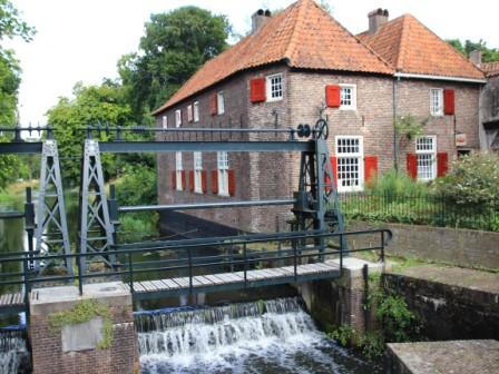
At the end of the Grote Spui, when you walk through the defense gate of the second city wall, you will see the Volmolen. Vollen in old Dutch means fulling.
Fulling, also known as tucking or walking, was a step in woolen cloth making which involves the cleansing of wool to make it thicker and stronger.
Initially it was done by tucking or walking wool in tubs, in 16th/17th century replaced by wind and water powered mills. This mill was built in 1645 and was powered by water streaming through the canal in front of the second city wall.
Continue on the Grote Spui and walk across the Eems at the pedestrian/bicycle bridge before the railway bridge (the bridge is a good spot to take a picture of the Koppelpoort).
–
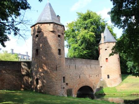
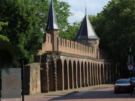
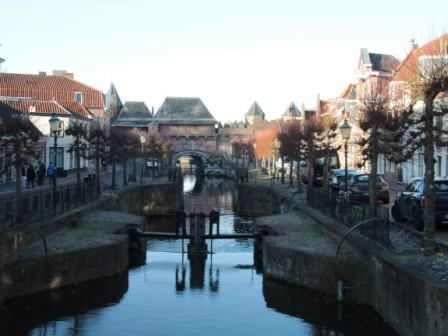
44. Koppelpoort – combined land and water defense gate (1380 – 1425)
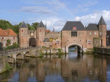
The Koppelpoort was build between 1380 and 1425 as part of the second city wall. It is the only remaining combined land and water gate In the Netherlands. The land and water gate were originally two separate structures.
The oldest references to this defense gate was not Koppelpoort, but Spuipoort (sluice gate). The name is could be derived from the old Dutch word ‘coppel’, which means meadows in old Dutch or ‘ koppel’ which means to combine in modern Dutch.
Two brooks (Lunterse and Barneveldse beek) join just before the other watergate (Monickendam) and feed tone of the shortest rivers in the Netherlands (the river Eems is only 19 kilometers long). The Eem was also called the Amer of which the name of Amersfoort is derived (ford at the river Amer). Take a left turn when across the bridge and walk back to Koppelpoort to continue on the Kleine Haag
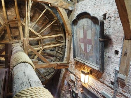
To raise and lower the gates, people simply walked in two gigantic wheels which (un)winded ropes around the connecting axis.
When the gate was lowered the wheel turned faster, because of the weight of the gates. Often causing people to fall over each other and break a limp. Because they used prisoners for this risky job, in Dutch a raddraaier also means trouble maker (thread-mill walter literally translates to wheel-turner).
On appointment, it is possible to walk the wheels of this thread-mill. Contact the tourist office (vvvamersfoort.nl/en) in advance.
–
45. Drieringen – beer brewery using medieval recipes (Kleine Spui 18)
The first reference of the beer brewing industry at Amersfoort is from 1323 when other Dutch cities complain about Amersfoort beer because they used hop instead of bog-myrtle. The right to grow and use bog-myrtle was given in to aristocracy. By using hop the beer brewers dodged taxes.
Amersfoort beer became fameous because of the use of hop and the relatively clean water of the Eem. Because of its success many breweries popped up around Amersfoort to piggy backed on the Amersfoort brand name. In 1528 the emperor Charles the fifth forbid the production of beer around Amersfoort to protect the reputation and quality of Amersfoort beer.
The Drieringen beer brewery builds on this heritage and offers beer tastings from Tuesday to Thursday from 15.00 to 20.00 and from Friday to Sunday from 13.00 to 19.30. Ask to include some of the beers which are made using medieval recipes (e.g. the Vuurvogel and ‘Amersfoort blond’).
Continue on the Kleine Spui and turn right at the end into the street called Westsingel (West canal).
–
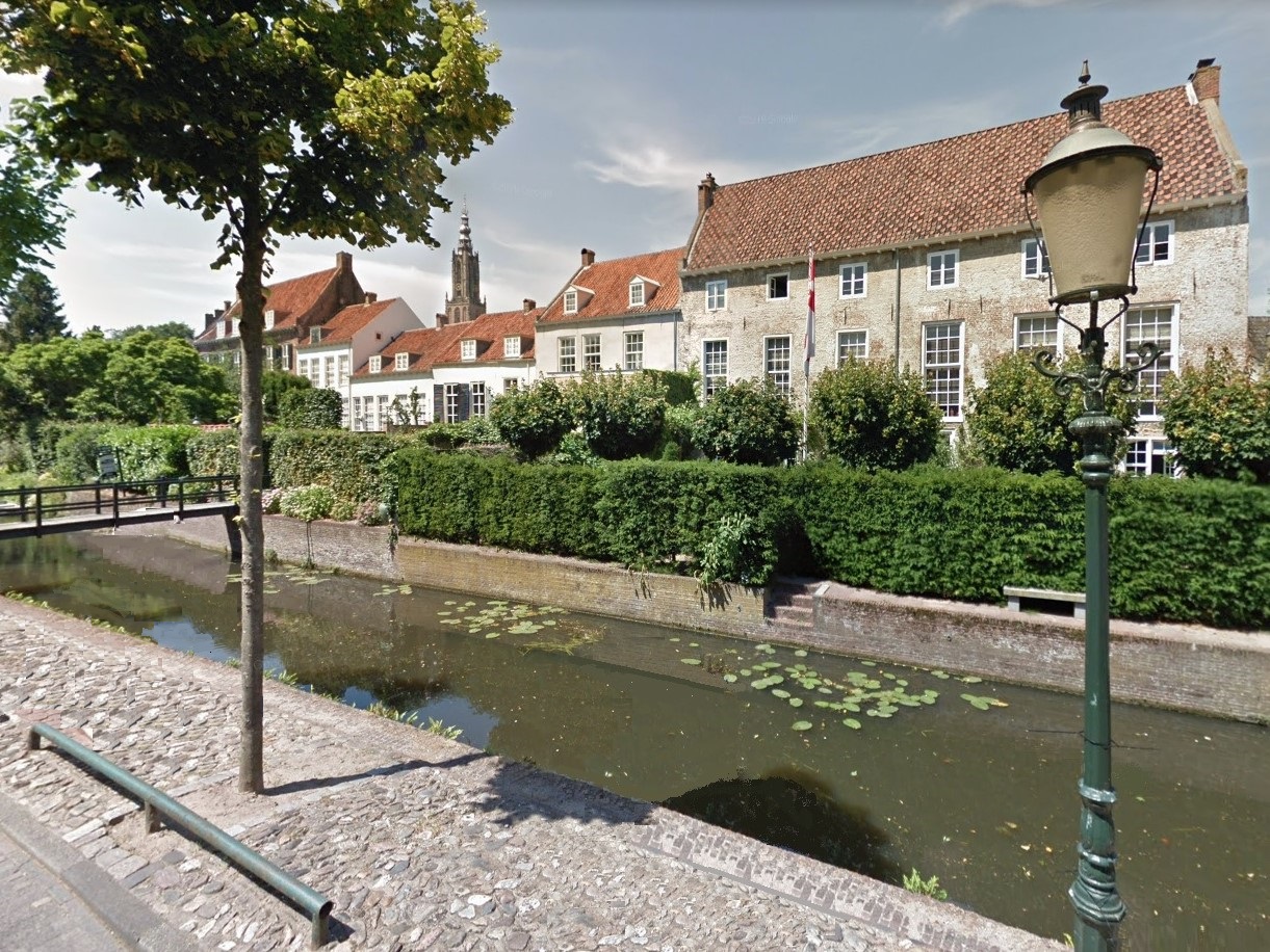
46 Museum Flehite (Westsingel 50)
Museum Flehite is the historical museum of the City of Amersfoort and the surrounding region Eemland. Besides local history it has rotating collections of (international) art. The Museum is open from Tuesday until Sunday from 11.00 until 17.00 hour.
The museum is located in three wall houses, which were build around 1540. The name Flehite refers to the name of this region used by Emperor Charles the Great in a certificate from 777. The facades of these building are in the typical Dutch white and brick neo-renenesance style of the Dutch Golden Century.
The buildings were pictured in 1671 by the local artist Withoos when he was contracted by the city council to paint the flourishing beer, tobacco and textile industries in Amersfoort. His most famous painting “View on Amersfoort” of four by two meters can also be seen in this museum.
Walk further on the Westsingel to the Mannenzaal (the church like building on number 47)
–
47 Mannenzaal – men’s rest home (Westsingel 47)
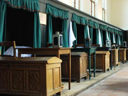
The history of this care and elderly center date back to 1390. The chapel and the Mannenzaal (men’s rest home) were build in 1535. The interior illustrates the luxury level of 19th century elderly care: a table and chair and a box and a bed.
In the eighteenth century the Saint Peter care and the Bloksland elderly home merged into the Saint Pieter & Bloksland Gasthuis. The facilities did not meet the new standards therefore a new building was constructed (number 48 on this tour)
The Vrouwenzaal (for woman) and Regentehuis (for the rich) sadly did not survive this renovation. The Mannenzaal is the oldest rest and care home for men in the Netherlands.
The Mannenzaal is open for public on Monday’s from 12.00 to 16.30 from May to October.
Continue on the Westsingel and take the first street on the right called ‘Achter Davidshof’.
–
48 St Pieters Bloksland Gasthuis – caring home (Achter Davidshof 1)
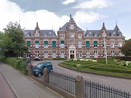
On this location the Sint Pieter (Saint Pete) caring home was built in 1393. Several buildings were added in the following centuries to accommodate the increased demand for care in Amersfoort.
In 1804 the St Pieter care house merged with the Bloksland care house and in 1907 most of the buildings were replaced by this neo renaissance style building with its brick and white façade.
The oldest active care home of the Netherlands is in Delft (dating back to 1252), but the Sint Pieters en Bloksland Gasthuis is the oldest rest home, still providing care on its original location.
In those days man and woman were separated. The 62 guests (caring home in old Dutch translates to guest home) were taken care of by a married couple assisted by just one maid who also cooked for the guests.
Turn around and walk into the park (see 49).
–
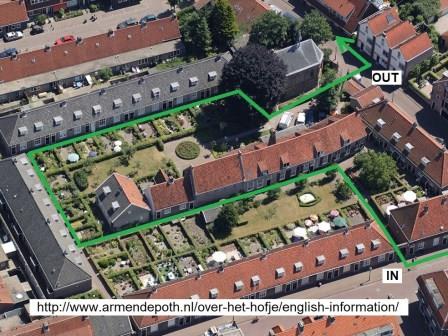
49 Grave of the last chief of Dejima (former Achter Davidshof graveyard)
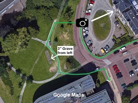
When the new City hall was build the Davidshof graveyard was removed, except for a few graves which are still located in the park behind the city hall.
At that time it was a a hyped up press story that the city was breaking its promise and contract with the people berried in one of the oldest graveyards of Amersfoort. During the black death pandemic many rich families died without living children. The city offered those people an eternal place to rest when they gave (a part of) their fortune to the city.
Some of these contracts survived time and forcing the city to keep its promise. This is the reason that you find a few graves in this park. One of them is Jan Cock Blomhoff. He was the last chiefl of the Dutch-Japanese trading isle Dejima (also mentioned at highlight 39 the Dutch East Indies Company houses). He and his second wife are buried in the third grave from the left, close to the two big chairs in the park. Walk back to road as indicated on the picture and take a right into the Stadhuisplein (city hall square).
Walk back as indicated in the picture to the city hall square (Stadshuisplein).
–
50 Observant monastery & city inn (Stadhuisplein 6)
In 1471 this location was given to a suborder of the the Franciscan monks called the Friars Minor. They believed that a stricter compliance with the rules of poverty and humility of Franciscus from Assisi lead to a purer form of spirituality.
Because these monks had the highest recorded encounters with Maria, they were also called the observant branche, which explains the name of this monastery. Story goes that extraordinary high rate of Maria encounters was attributed to their consumption of Absinthe. An alcoholic beverage known for his hallucinating effects.
After 1580 it was used as the city’s inn and had famous guests like tsar Peter the Great of Russia. It is now is an conference center, with meeting rooms facilitating up to 150 people.
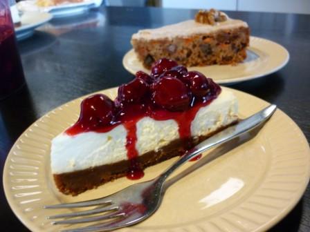
Continue on the Stadhuisplein to the Hellestraat 49 and reward yourself with delicious home made food and a refreshing beverage of lunchroom Lijn49.
–
Congratulations, you successfully completed the self-guided LIJN49 city walk.
You burned enough calories to treat yourself on one of my homemade Dutch delicacies. For every hour you walked, you burned 4 kilo-calories per kilogram body weight. So when you walked for two hours and weight 65 kilograms, you burned 520 kcal. That is the equivalent of an hour exercising in the gym. Time to reward yourself and have a look at the lunchroom LIJN49 menu.